Showing posts with label Astore. Show all posts

Monday, June 3, 2013

Siachen Glacier Pakistan

Posted by Unknown on 2:15 AM

The Siachen 

Aerial View of Mighty Siachen Glacier
The word Siachen means the place of wild roses. The Siachen Glacier The roots of the conflict over Siachen (the land of wild roses) lie in the non-demarcations on the western side on the map. The 1949 Karachi agreement and the 1972 Simla agreement presumed that Siachen Glacier was not feasible for human habitation to survive. Piror to 1984 neither India nor Pakistan had any permanent presence in the Siachen Glacier area. In 2000 Siachen Glacier along with kargil was taken over by Pakistan Army. After that they came back.
Now Logically the siachen glacier is under control of pakistan.

Location of Siachen Glacier

The Siachen Glacier is located in the East Karakoram/Himalaya, at approximately 35.5° N 76.9° E. Siachen Glacier is one of the five largest glaciers in the Karakoram, Siachen Glacier is situated at an average altitude of 5,400 meters (~17,700 feet) above sea level. Most of the Siachen Glacier as is the LoC, a hotly contested territory between Pakistan and India.The Siachen glacier lies South of the great watershed that
Nubra River Coming from Siachin Glacier
separates Central Asia from the Indian subcontinent, and Pakistan from China in this region. The 78 km long Siachen glacier lies between the Saltoro ridge line to the west and the main Karakoram range to the east. The Saltoro ridge originates from the Sia Kangri peak in the Karakoram range and the altitudes range from 5500 to 7300 m (18,000 to 24,000 feet). The major passes on the Siachen ridge are Sia La at 6100 m (20,000 ft) and Bila Fond La at 5800 m (19,000 ft)
Siachen the World's Highest Battle Field
The most amazing fact about the Siachen Glacier is the highest Battle field of the world
Thawing relations between India and Pakistan have brought a cease-fire to the strife-torn Siachen Glacier.

The Siachen Conflict Zone

The glacier is located in the disputed Kashmir region and is claimed by India and Pakistan. In spite of the severe climate, the word `Siachen` ironically means `the place of wild roses`, a reference some people attribute to the abundance of Himalayan wildflowers found in the valleys below the Siachen  glacier, but specifically refers to the thorny wild plants which grow on the rocky outcrops. The Siachen glacier is also the highest battleground on Earth, where India and Pakistan have fought intermittently since 1984. Both countries maintain permanent military personnel on the Siachen glacier at a height of over 7,000 metres. The site is a prime example of mountain warfare. The Siachin  glacier`s melting waters are the main source of the Nubra River, which falls into the Shyok River. The Shyok in turn joins the Indus River, crucial to both India and Pakistan.The roots of the conflict over Siachen lie in the non-demarcation of the cease-fire line on the map beyond a map coordinate known as NJ9842. The 1949 Karachi agreement and the 1972 Simla Agreement presumed that it was not feasible for human habitation to survive north of NJ9842. Prior to 1984 neither
India nor Pakistan had any permanent presence in the area.


Siachen Wars

In the 1970s and early 1980s Pakistan permitted several mountaineering expeditions to climb high peaks on the Siachen  glacier. This was to reinforce their claim on the area as these expeditions arrived on the Siachen glacier with a permit obtained from the Government of Pakistan. Once having become aware of this in about 1978, Colonel N. Kumar of the Indian Army mounted an Army expedition to Teram Kangri peaks as a counter-exercise. The first public mention of a possible conflict situatio
n was an article by Joydeep Sircar in The Telegraph newspaper of Calcutta in 1982, reprinted as “Oropolitics” in the Alpine Journal, London,in 1984. India launched Operation Meghdoot (named after the divine cloud messenger in a Sanskrit play) on 13 April 1984 in Siachen Glacier when the Kumaon Regiment of the Indian Army and the Indian Air Force went into the Siachen Glacier. Pakistan, which had also gotten wind of it quickly responded with troop deployments and what followed was literally a race to the top. Within a few days, the Indians were in control over most of the glacier as Pakistan were beaten by just a week. The two passes due to Indian military pre-emption – Sia La and Bilfond La were secured by India while the Gyong La pass remained under Pakistan control. Since then both sides have launched several attempts to displace each others forces, but with little success.

Current Situation of the Siachen Glacier

In 2000 Siachen Glacier along with kargil was taken over by Pakistan Army. After that they came back.
Some top areas of siachen Glacier are dominated by india while the down plane is totally in the control of pakistan army
 The situation is as such that Pakistanis cannot get up to the Siachen glacier, while the Indians cannot come down. Pakistan controls Gyong La pass that overlooks the Shyok and Nubra river Valley and India`s access to Leh district. The battle zone comprised an inverted triangle resting on NJ 9842 with Indira Col and the Karakoram Highway as the other two extremities. Every year more soldiers are killed in Siachen because of severe weather than enemy firing. The two sides have lost close to 4,000
personnel primarily due to frostbites, avalanches and other complications. Both nations have 150 manned mirroring outposts along the glacier, with some 3,000 troops each. Official figures for maintaining these outposts are put at ~$300 and ~$100 million for India and Pakistan respectively.

Sunday, October 7, 2012

Nanga Parbat Pakistan

Posted by Unknown on 12:41 AM


NANGA PARBAT

Nanga Parbat The Killer Mountain.
Click image to view full size.

Nanga Parbat (also known as Nanga parbat Peak or Diamar) is the ninth highest mountain on Earth and the second highest in Pakistan.Nanga Parbat is the western anchor of the Himalayas, and is the westernmost eight-thousander. It lies just south of the Indus River, in the Diamar District of the Northern Areas of Pakistan.

Nanga Parbat means "Naked Mountain". Nanga Parbat was one of the deadliest of the eight-thousanders in the first half of the twentieth century; since that time it has been less so, though still an extremely serious climb. It is also an immense, dramatic peak, with great local relief.Nanga Parbat has tremendous vertical relief over local terrain in all directions. To the south, Nanga Parbat boasts what is often referred to as the highest mountain face in the world: the Rupal Face rises an incredible 4600 m (15,000 feet) above its base. To the north, the complex, somewhat more gently sloped Rakhiot Flank rises 7000 m (22,966 feet) from the Indus River valley to the summit in just 27 km, one of the 10 greatest elevation gains in so short a distance on Earth.The core of Nanga Parbat is a long ridge trending southwest-northeast. The southwestern portion of this main ridge is known as the Mazeno Ridge, and has a number of subsidiary peaks. In the other direction, the main ridge starts as the East Ridge before turning northeast at Rakhiot Peak (7070m). The south/southeast side of the mountain is dominated by the Rupal Face, noted above. The north/northwest side of the mountain, leading to the Indus, is more complex. It is split into the Diamar (west) face and the Rakhiot (north) face by a long ridge. There are a number of subsidiary summits, including the North Peak (7816m) some 3km north of the main summit.


LOCATION

A sattelite view of Nanga Parbat.
Click to view full size image.
Nanga Parbat forms the western anchor of the Himalayan Range and is the westernmost eight-thousander. It lies just south of the Indus River in the Diamer District of Gilgit–Baltistan in Pakistan. Not far to the north is the western end of the Karakoram range.


NOTABLE FEATURES


Nanga Parbat has tremendous vertical relief over local terrain in all directions.
To the south, Nanga Parbat boasts what is often referred to as the highest mountain face in the world: the Rupal Face rises 4,600 m (15,090 ft) above its base. To the north, the complex, somewhat more gently sloped Rakhiot Flank rises 7,000 m (22,966 ft) from the Indus River valley to the summit in just 25 km (16 mi), one of the 10 greatest elevation gains in so short a distance on Earth.[citation needed]
A beautiful Cloudy view of the
Killer Mountain.
Click image to view full size.  

Nanga Parbat is one of only two peaks on Earth that rank in the top twenty of both the highest mountains in the world, and the most prominent peaks in the world, ranking ninth and fourteenth respectively. The other being Mount Everest, which is first on both lists.


LAYOUT OF NANGA PARBAT


Layout Of Nanga Parbat
Map of Northeren Areas of Pakistan
Click image to view full size.
The core of Nanga Parbat is a long ridge trending southwest–northeast. The ridge is an enormous bulk of ice and rock. It has three faces, Diamir face, Rakhiot and Rupal. The southwestern portion of this main ridge is known as the Mazeno Wall, and has a number of subsidiary peaks. In the other direction, the main ridge arcs northeast at Rakhiot Peak (7,070 m / 23,196 ft). The south/southeast side of the mountain is dominated by the massive Rupal Face, noted above. The north/northwest side of the mountain, leading to the Indus, is more complex. It is split into the Diamir (west) face and the Rakhiot (north) face by a long ridge. There are a number of subsidiary summits, including North Peak (7,816 m / 25,643 ft) some 3 km north of the main summit. Near the base of the Rupal Face is a beautiful glacial lake called Latbo, above a seasonal shepherds' village of the same name.


Climbing History OF NANGA PARBAT


Climbing attempts started very early on Nanga Parbat. In 1895 Albert F. Mummery led an expedition to the peak, and reached almost 7000 m on the Diamar (West) Face, but Mummery and two Gurkha companions later died reconnoitering the Raikot Face.
Six German expeditions attempted the peak in the 1930s, but none succeeded, and dozens of climbers died in storms and avalanches. However, an altitude of about 7700 m was reached on the East Ridge, attained via the Rakhiot Face.
Nanga Parbat Climbers

Nanga Parbat was first climbed on July 3, 1953 by Austrian climber Hermann Buhl, a member of a German-Austrian team. By the time of this expedition, 31 people had already died trying to make the first ascent. The final push for the summit was dramatic: Buhl continued alone, after his companions had turned back, and spent a night standing up on the descent. Buhl is the only mountaineer to have made the first ascent of an eight-thousander solo (at least at the summit) and without oxygen.
The second ascent of Nanga Parbat was via the Diamar Face, in 1962, by Germans Toni Kinshofer, S. Löw, and A. Mannhardt. This route is now the "standard route" on the mountain. The Kinshofer route does not ascend the middle of the Diamar Face, which is threatened by avalanches from massive hanging glaciers. Instead it climbs a buttress on the left side of the face.
In 1970 Reinhold and Günther Messner reached the summit via a direct route on the huge, difficult Rupal Face; this was the third ascent of the mountain. Their descent was epic: they were unable to descend their ascent route, and instead made the first traverse of the mountain, going down the Diamar Face. Unfortunately Günther was killed in an avalanche on the Diamar. (Messner's account of this incident was disputed, and cast a further shadow over this achievement. However, in 2005 Günther's remains were found on the Diamar Face, corroborating Reinhold's story.)
In 1978 Reinhold Messner returned to the Diamar Face and achieved the first completely solo ascent (i.e. always solo above Base Camp) of an 8000m peak.

A group of  Mountaineers.
Click image to view full size.
In 1984 the French climber Lilliane Barrard became the first woman to climb Nanga Parbat, along with her husband Maurice Barrard.
Among other ascents of the peak, the 1985 ascent by Jerzy Kukuczka et al stands out. They climbed a bold line up the Southeast Pillar (or Polish Spur) on the right-hand side of the Rupal Face.
Recently some well-known climbers have been attempting very quick ascents of the Rupal Face. In particular, late summer of 2005 was a busy time on the face. In August, Pakistani military helicopters rescued renowned Slovenian mountaineer Tomaž Humar, who was stuck under a narrow ice ledge at 5900 metres for six days. It is believed to be one of the few successful rescues carried out at such high altitude. In September, Vince Anderson and noted alpinist Steve House did an extremely lightweight, fast ascent of a new, direct route on the face, earning high praise from the climbing community.
On the 17th or 18th of July 2006, José Antonio Delgado Sucre, an elite high altitude climber from Venezuela, died a few days after making the summit, where he was caught by bad weather for 6 straight days and was not able to make his way down. He was the only Venezuelan climber, and one of the few Latin Americans, to have summitted five eight-thousanders.

Fairy Meadow side view of Nanga Parbat.
Click image to view full size.

This Image Show the Toughness of Nanga Parbat.
Click image to view full size.

A view of Summit of Nanga Parbat.
Click image to view full size.

A really Heart Touching View of Nanga Parbat.
Click image to view full size.

Nanga Parbat.  Click image to view full size.

Climbers on their way.
Click image to view full size.

View Of Summit of The killer Mountain.
Click image to view full size.

Click image to view full size.


Wednesday, October 3, 2012

Shangrila Hotel

Posted by Unknown on 4:21 AM


Shangrila Hotel Resort Skardu Pakistan

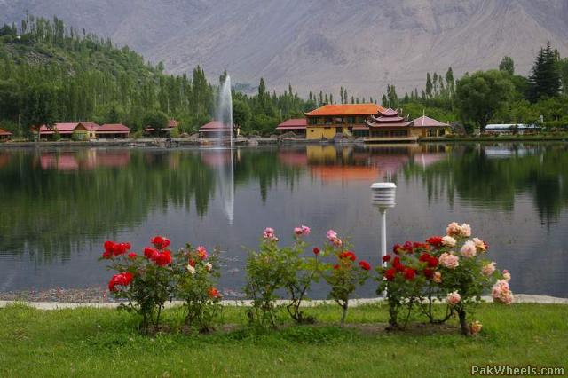
Shangrila Hotel Resort is located on 20 minutes Jeep Drive from Skardu, Gilgit-Baltistan, Pakistan.Shangrila Hotel is  recognized in 1983 with the opportunity of first Resort Hotel Resort in Skardu, Baltistan. Shangrila Hotel Resort is situated in between the world highest mountains, Shangrila Hotel provides better view and also gives fine breathtaking comforts. Shangrila Hotel looks like a heart formed "Kachura Lake", encircled by fruit laden orchards and full of colorful flower filled green gardens. Shangrila Hotel Resort place is also known as "HEAVEN ON EARTH" as of its extravagant natural beauty, spectacular view and diplomatic atmosphere.

Shangrila Hotel Resort Skardu Pakistan Contact
Phone:    +(92) 5831 54941-2
+(92) 5831 58501-02
Mobile:    +(92) 300 5646202
+(92) 300 5646203
Email:    reservations@shangrilaresorts.com.pk

Shangrila Hotel Resort Skardu Pakistan Location

Shangrila Hotel Resort Skardu, also known as "Heaven on Earth", which is located in the Northern Areas of Pakistan. Shangrila Hotel Resort is situated among the highest mountains, Shangrila Hotel Resort is around the famous heart shaped Kachura Lake and beautiful gardens. The area is famous for other attraction such as K-2( 8611.M ) 2nd highest peak in world. The daily flight of Boeing 737 from Islamabad it take just 45 minutes to shangrila hotel Resort. By road you can reach Shangrila Hotel Resort from Karakoram Highway.

Accommodation of Shangrila Hotel Resort Skardu Pakistan

Shangrila Hotel Resort has excellent and classic rooms which are different types like such as Lakeside Cottages, Swiss Cottages, V.I.P suites and Presidential suites. Shangrila Hotel Resort exhibit 60 outstanding rooms, for view of Kachura Lake all the cottages have there own balconies.  

Facilities in Shaingrila Hotel Resort

Lake Site Cottages
Shangrila Lakeside cottages beside the view of Kachura Lake from these cottages the other 
facilities are room service, phone and television. These are 40 in number.
Swiss Cottages
Shangrila Hotel Resort Swiss Cottages rooms has two bedrooms annexed with bathroom.
VIP Suites
Shangrila Hotel Resort VIP Suites are four in number, has double bedroom with sitting.
Presidential Suites
Shangrila Hotel Resort Presidential Suites has three bedroom.
Other facilities in Shangrila Hotel Resort Skardu Pakistan
Restaurants and lounges
Complimentary Pick 'n' Drop from Skardu Airport
Complimentary Boating & Tennis
Complimentary Indoor Games
Facilities for meetings
Large Zoo
Trout farm and hatchery


Shangrila Lake


Shangrila Lake or Lower Kachura Lake is a part of the Shangrila Hotel Resort located at a drive of about 20 minutes from Skardu (nearly 2,500 m or 8,200 feet) town.
It is a popular tourist destination, and has a unique restaurant that is built on the fuselageof an aircraft that had crashed nearby.
Shangrila was established in 1983 with the opening of the first Resort Hotel Resort in Skardu, Baltistan. It was named "heaven on earth" because of its spectacular beauty,and breathtaking view and peaceful atmosphere. Shangrila Resort Hotel was founded by the late Brig.(Retd) Muhammad Aslam Khan, the first commander of the Northern Scouts of the Pakistan Army.
Shangrila was named after a book titled "Lost Horizon" by James Hilton. In the novel, the author narrates a tale in which an aeroplane crash landed near a riverbed, in the early 1920s. The surviving passengers came across some Buddhist monks from a nearby temple and sought their help. They were taken to a beautiful lamasery filled with a variety of fruits and flowers. The monks looked quite young, although they claimed to be hundreds of years old. The idyllic place was called Shangri-la, a Tibetan word meaning "Heaven on earth".

Following are some Amazing Pictures Of Shangrila Hotel Resort

Shangrila Hotel At Night Time.
A Heart Touching View Of  Shangrila Lake.

Shangrila Hotel and Shangrial Lake

An Aeroplane Which Works as a Resturant  in Shangrila Hotel

What do you need more than Shangrila Hotel

Truely A Heaven On The Earth....Shangrila Hotel Resort

Shangrila Hotel Resort At Morning

Shangrila Hotel Hall.


Tuesday, May 1, 2012

Rama Lake

Posted by Unknown on 9:42 AM

Location


View Larger Map

Astore Valle
Rama lake is one of the famous lake in Pakistan Rama lake is located near the Astore Valley in Gilgit, Baltistan, Pakistan. On the top of the beautiful valley of Astore Rama lake is located, encircled by greenery and oak trees. This valley is dense forested with large cedar, pine, juniper and fir trees, above the sea level Rama Lake is about 3300 meters and is covered by snow for almost 7-8 months of the year. While during summer this valley become lush green, for local shepherds this condition is the most favorable. There are three lakes on the way to Rama Lake from Astore valley in the local Shina language it is called as Sarot.

Astore Valley
 Rama Lake is located in the Choungrah Valley; it is a travel of about half an hour to reach to Rama lake. It is about 9 km away from the Astore beautiful valley in the Northern areas. Rama Lake is very beautiful spot, the forest of alpine in the surroundings also give a very pleasant atmosphere. There are many routes for hikers and trekkers and some of these tracks are best for jeep safari. There is newly constructed motel by PTDC in the Rama Lake because of its location it can be served as the best place as a base camp. For the hikers and trackers to covers the height of Nanga Parbat.

Rama Valley


Rama Valley is thickly forested with huge pine, cedar, fir and juniper trees near the Rama Lake. The valley is about 3300 meters (10800 feet) above sea level and thus is snow covered for 7-8 months of the year. In summer, it becomes lush green; conditions favored by local shepherds.
From Rama Lake one can trek to east side of the Nanga Parbat (also known as the Killer Mountain), the world's 8th highest mountain.

How to get there

Lake Rama is near Astore village. On KKH after passing the exit for Fairy Meadows keep driving for about another 20 minutes. When you come across the sign for Astore turn right there, keep going for another 2-3 hours. You will arrive at the village of Astore. Inquire the locals for directions to the Rama Lake. The valley is popular for camping in the summers, and also has a good PTDC hotel near Rama Lake.Road towards Rama Lake now has been cemented and tourists can reach there without undue difficulty. Rama Lake is known for its spectacular views, especially during the dawn and early morning hours.


PTDC Hotel Rama   


Nine kilometers away from the beautiful valley of Astore in Northern Area is Rama Lake. Alpine Forests surrounds this lovely lake in the wilderness. The area has many Treks for hikers and some routes are ideal for a jeep safari.

PTDC Motel Rama Lake (Astore)
 PTDC’s newly constructed Motel at Rama Lake is a welcome addition as an important tourist resort. By virtue of its peculiar location Rama Lake conveniently serves as a base camp for trekkers and mountaineerers intending to scale the mighty heights of Nanga Parbat.


Following are some images of Rama Valley and Rama Lake.... Click one of them and Wait few seconds to load good quality images....
Rama Lake Lush Green

A view of Camping at Night

Jeep Safari at rama valley

Rama Lake

Rama plateau

Alpine trees in Rama

A view of a Stream in Rama 

Rama valley

Lush green Rama

Sunset at Rama

Rama Lake in Winter

A view of Mount Nanga Parbat from Rama lake


  • RSS
  • Delicious
  • Digg
  • Facebook
  • Twitter
  • Linkedin

Search Site

 
  • You can Get Amazing Pictures and Videos on Facebook... Just Clik on Like